Materials Spotlight: Montessori Maps
- kfinck6
- May 7, 2021
- 2 min read
What does the cultural area of the Montessori classroom encompass?
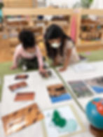
Montessori cultural lessons expose children to different people and their cultures. These lessons include how people have adapted to different climates, their homes, clothing, food, and customs. Through continent and cultural studies, children learn about the interconnectedness of all life on earth. The highlight of the cultural area in a Montessori classroom are the beautiful wooden maps. These puzzle maps are wooden puzzles divided up by continents, countries, or states. They are not traditional jigsaws that fit into one another, but rather each piece is a geographical mass. A child will begin their exploration of the continents by working with the world map. They will continue their journey around the world as they explore each continent and narrow in on countries, states, and capitals.

Can you explain the sequence of the order in which each map is introduced?
Sure! The Continent Map is introduced first and is often heavy for the smallest of children to navigate, requiring great care and caution as it's moved through the classroom. First, the child will remove the pieces of the Continent Map individually, as the teacher introduces the name for each continent. The child can feel the shape of the continent, compare the sizes between them, and ultimately rebuild the map outside of its puzzle frame. After many experiences with this map a child is ready to continue with their exploration and move to the puzzle map of North America followed by United States of America, South America, Australia, Europe, Africa and Asia.


Do the colors of each continent have a specific purpose?
The color of each continent differs, and becomes the code for materials pertaining to that continent. In later lessons, for example, the child might be introduced to a red pouch containing pictures of children in Europe. The child can compare those pictures to pictures from the green pouch, Africa, or the brown pouch, Australia. These packets will be offered for all sorts of classifications: food, children, clothing, major landmarks, natural features, or political buildings. The child comes to learn how much we have in common with each other around the world, and simultaneously comes to understand the vastness of our earth and the diversity of life it bears.
Are there any extensions for this work?
Yes, there are and these extensions can be found happening in almost every Primary classroom on any given day. The child can re create their own hand drawn version of each map, color it in to match the wooden map, label it, and go even further to use an atlas for a country or state's capital. A Kindergarten child may even learn a country or state's flag and flower, learn how to read a map legend, and look for mountains, lakes and rivers.


